Before European Settlement, this area was originally inhabited by the Tattyara and Wotjobaluk tribe who followed the water trail through the area when the swamps were full.
There are several indigenous sites in the area that are worth visiting including:
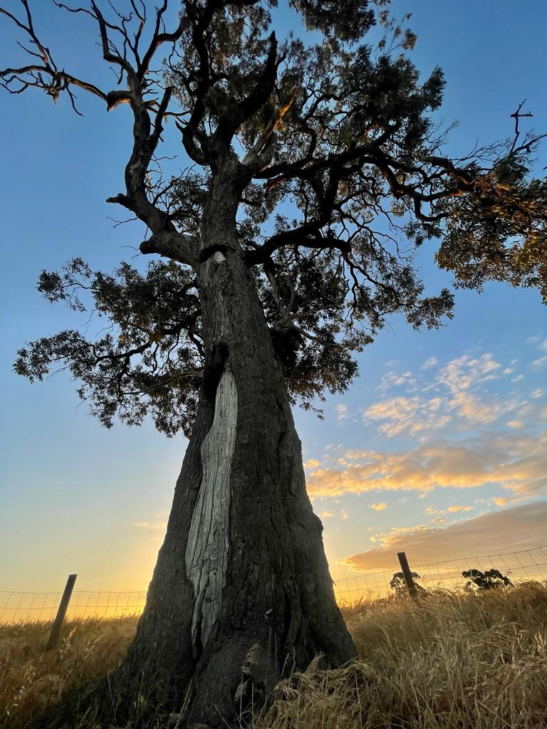
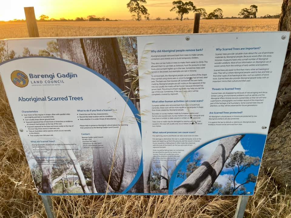
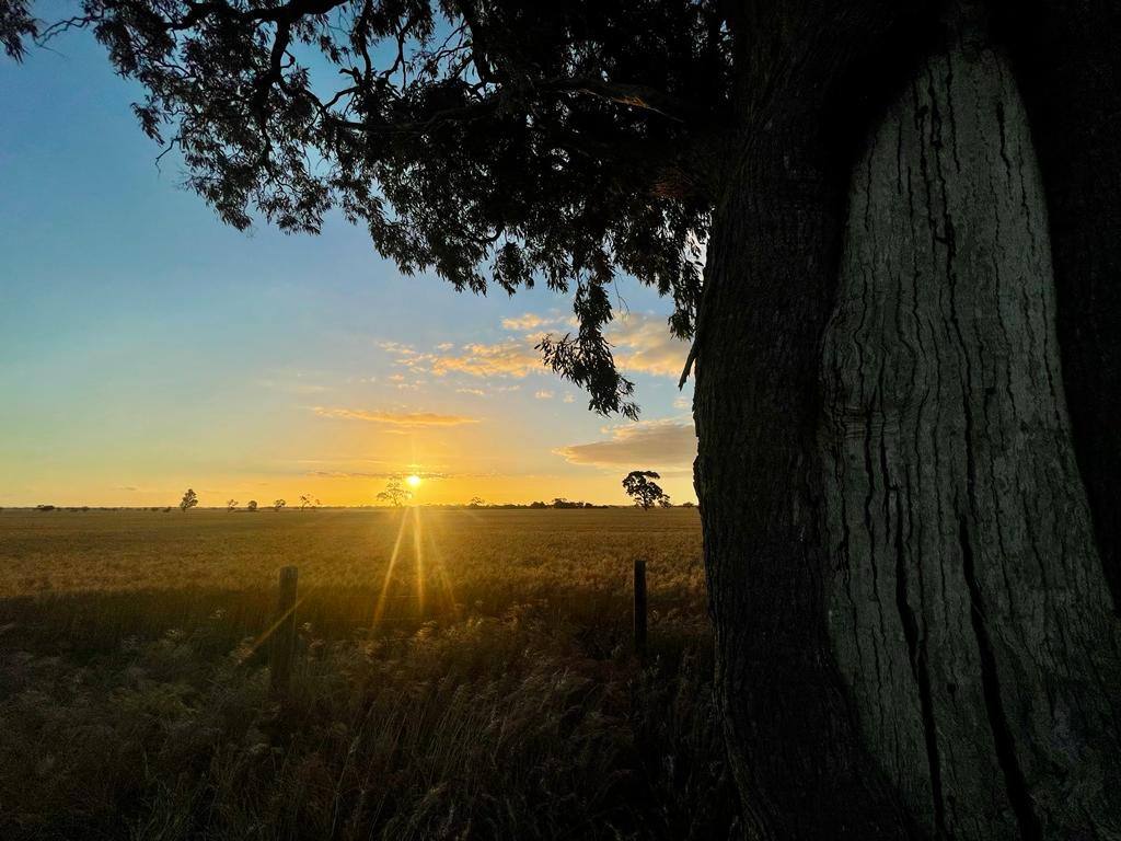
The scar tree, this makes for a pleasant a short walk from the Caravan park. It is believed to be a message tree, located on South Kaniva Rd, just off Budjik St. (Budjik means Stone Axe and was the name the town was originally known as.)
Mooree Reserve was used as a camping ground, although all the scar trees have been removed, many locals comment that it still retains a special presence of place. Poocher Swamp near Bordertown is well worth a visit too. Nhill swamp wildlife reserve was their spirit place and corroboree ground, it is still a peaceful and tranquil place to visit
Bill's Gully: the 1932 Souvenir Booklet by FK McKenzie contains an article entitled 'Natives' Hunting Ground'. This provides interesting insight into a sacred coroboree ground in Nhill and tribal law. A copy of this is on the Bill's Gully page.
In the area:
Excerpt from Tattyara: A history of Kaniva District by Les Blake
"On Henry Wade's plan of 1847 the Tattyara was marked. The name, which has various spellings, derived from that of the Tyatyalla tribe of Aborigines. The native words tyar and tyalla referred respectively to 'earth' and 'mallee scrub' and, because the tribal hunters could always find animals and plants for food and water from soaks and springs hereabouts, men named this pleasant land Tattyara, the good country. Following complaints from settlers in the 1840s that no proper boundary line then existed between the colonies, the governments of New South Wales and South Australia sent from Portland Henry Wade's survey party to mark on the ground the position of the 141st meridian which the British Government in 1834 had determined should be the boundary. The section of this line which affected Victoria (known as Port Phillip District until 1851) lay between the south coast and the Murray River. With Wade in 1846 went surveyor Edward Riggs White to represent South Australian interests."
Excerpt from Tatiara Heritage Study
It is a mistake to look at the Tatiara district on a State map, and see it only in relation to its surrounding semi-circle of South Australian towns - Pinnaroo, Coonalpyn, Kingston, Naracoorte -for the Tatiara has much closer neighbours. The towns of Bordertown and Wolseley, closest to the border, are mirrored by their Victorian equivalents of Kaniva and Serviceton just a few kilometres to the east. Like most people who live on borders, the residents of the Tatiara have always felt a sense of community with their neighbours in the western district of Victoria, and for a time in the nineteenth century there was a movement to form a new breakaway province called Princeland, made up of the Western District and the South-east of South Australia. (O'Connor 2001, p. 509) In the process of this long acquaintance, the people of the Tatiara have adopted some cultural traits more characteristic of Victoria than South Australia.
There are several indigenous sites in the area that are worth visiting including:
The scar tree, this makes for a pleasant a short walk from the Caravan park. It is believed to be a message tree, located on South Kaniva Rd, just off Budjik St. (Budjik means Stone Axe and was the name the town was originally known as.)
Mooree Reserve was used as a camping ground, although all the scar trees have been removed, many locals comment that it still retains a special presence of place. Poocher Swamp near Bordertown is well worth a visit too. Nhill swamp wildlife reserve was their spirit place and corroboree ground, it is still a peaceful and tranquil place to visit
Bill's Gully: the 1932 Souvenir Booklet by FK McKenzie contains an article entitled 'Natives' Hunting Ground'. This provides interesting insight into a sacred coroboree ground in Nhill and tribal law. A copy of this is on the Bill's Gully page.
In the area:
- Dimboola Historical Museum is located in the old courthouse at 67 Lloyd St and has information on the local Aboriginals who lived along the Wimmera River.
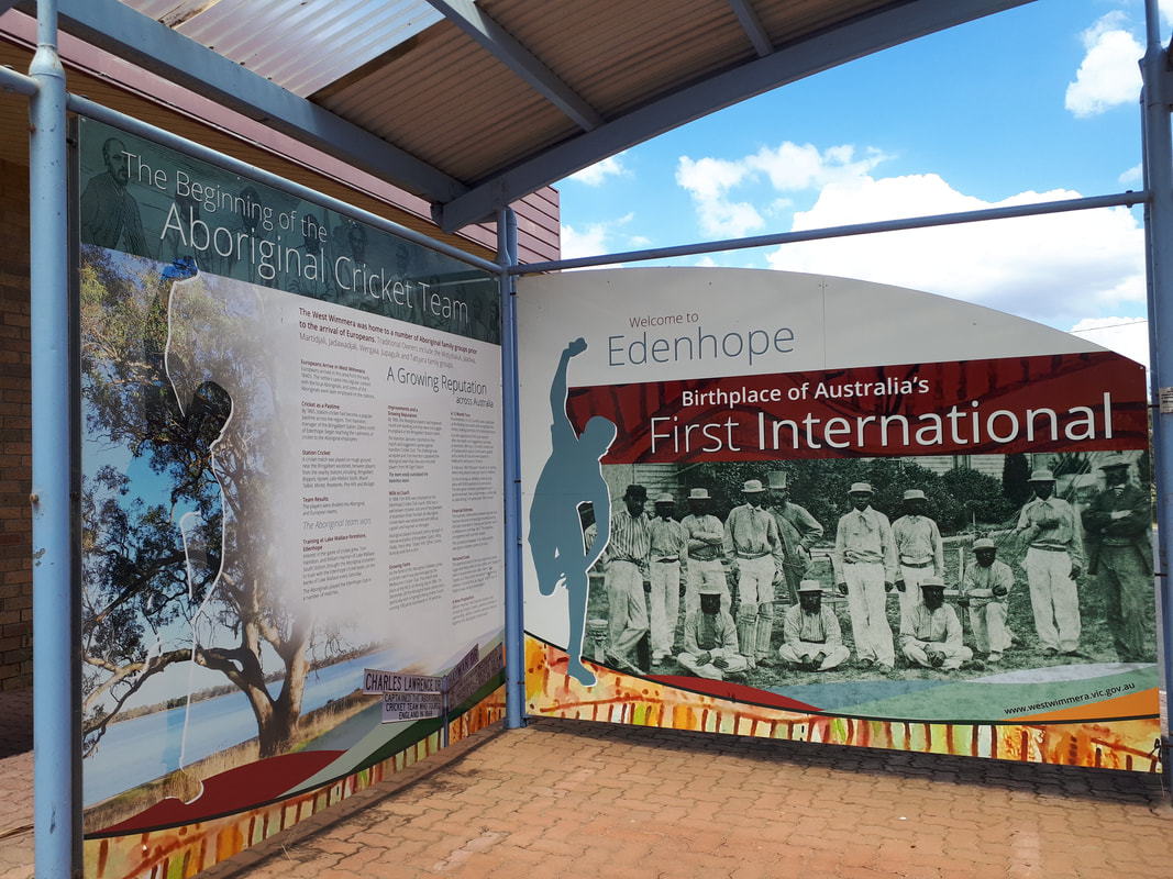
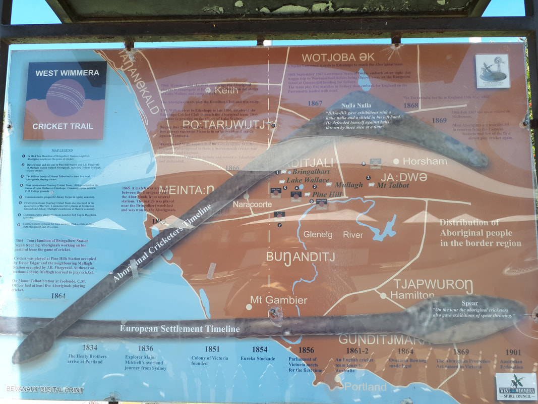
- Follow the Aborginal Cricket Trail, through West Wimmera.
- Harrow Interpretive Centre tells the story of Johnny Mullagh and the first Australian cricket team who toured England in 1868 and practiced on Lake Brigalbert.
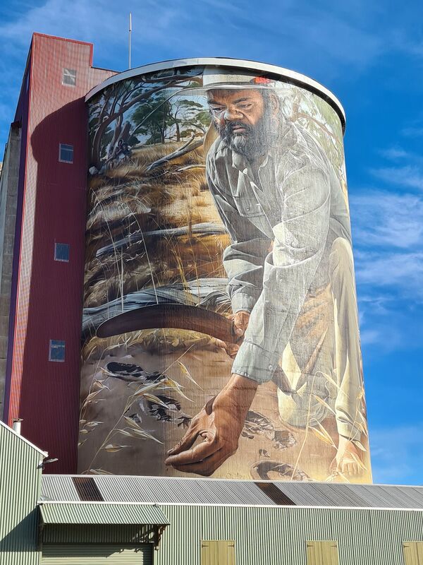
- The Horsham silo tells the story of Dick-a-Dick, a Wotjobaluk tracker responsible for finding the three Duff children lost in the Australian bush for 9 days in 1864. A cairn at Jane Duff Highway Park commemorates the site on the Natimuk-Frances Rd.
- Budj Bim World Heritage Site is well worth a visit. Tours are very popular must be booked in advanced.
- The Wimmera Pioneer Museum in Jeparit is open daily and has an interesting display of artefacts from the area along with its main attraction of a pioneer village. This is located close to Lake Hindmarsh and the Wimmera River. Stories from the nearby Ebeneezer Mission, established 1859, give great insight into this era.
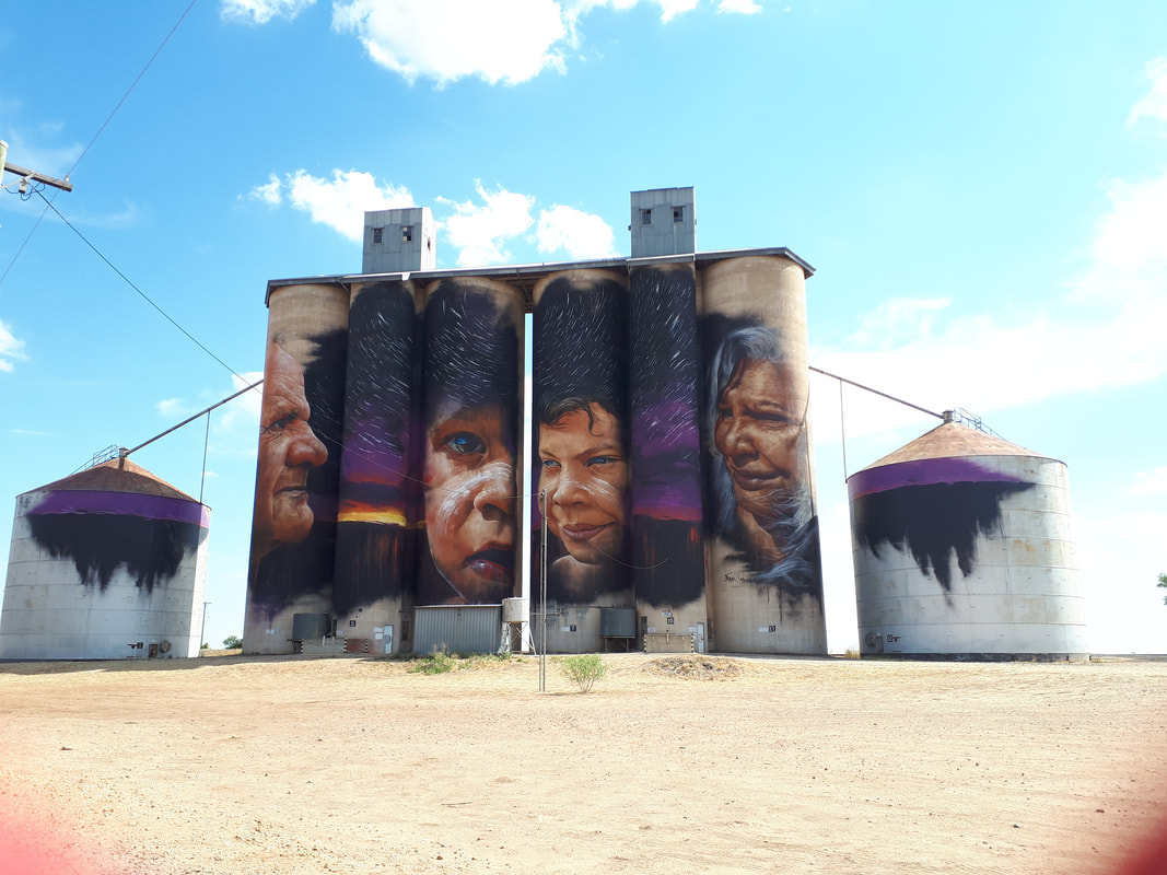
- Sheep Hills Silos features an Indigenous mural painted by Adnate. Scroll down for the video.
Excerpt from Tattyara: A history of Kaniva District by Les Blake
"On Henry Wade's plan of 1847 the Tattyara was marked. The name, which has various spellings, derived from that of the Tyatyalla tribe of Aborigines. The native words tyar and tyalla referred respectively to 'earth' and 'mallee scrub' and, because the tribal hunters could always find animals and plants for food and water from soaks and springs hereabouts, men named this pleasant land Tattyara, the good country. Following complaints from settlers in the 1840s that no proper boundary line then existed between the colonies, the governments of New South Wales and South Australia sent from Portland Henry Wade's survey party to mark on the ground the position of the 141st meridian which the British Government in 1834 had determined should be the boundary. The section of this line which affected Victoria (known as Port Phillip District until 1851) lay between the south coast and the Murray River. With Wade in 1846 went surveyor Edward Riggs White to represent South Australian interests."
Excerpt from Tatiara Heritage Study
It is a mistake to look at the Tatiara district on a State map, and see it only in relation to its surrounding semi-circle of South Australian towns - Pinnaroo, Coonalpyn, Kingston, Naracoorte -for the Tatiara has much closer neighbours. The towns of Bordertown and Wolseley, closest to the border, are mirrored by their Victorian equivalents of Kaniva and Serviceton just a few kilometres to the east. Like most people who live on borders, the residents of the Tatiara have always felt a sense of community with their neighbours in the western district of Victoria, and for a time in the nineteenth century there was a movement to form a new breakaway province called Princeland, made up of the Western District and the South-east of South Australia. (O'Connor 2001, p. 509) In the process of this long acquaintance, the people of the Tatiara have adopted some cultural traits more characteristic of Victoria than South Australia.
Kaniva, first and last highway town in Victoria.
|
|